Every house begins with a piece of land.
40'552 undeveloped plots (vacant lots) · around 7'510 ha of plot area · 70 % in residential zones
In 1'349 municipalities in 18 cantons, as of 11.11.2026. Counted from official geodata: plots in the building zone without buildings where a building envelope of at least 200 m² remains after the boundary distances; the area shown is the plot area.
Building land is scarce, but still around. Much of it has simply not been found.
Zone, restrictions, land registry, building authority: everything at a glance. For everyone who wants to buy a building plot and build their own home: find building-zone plots, whether or not they are advertised for sale. Dossiers from CHF 60, no account needed, no subscription.
Bauland-Scout analyses official geodata (cadastre, zoning plan, cantonal GIS) and shows plots of land in the building zone (the area in which the municipality permits construction) that are identified as undeveloped in these data and automatically cross-checked against official registers. A dossier (a plot report you can print as a PDF) sets out the zone, restrictions, a modelled development potential and the official route to the owner. Not an estate agent, not a listings portal.
Bauland-Scout does not sell land; any purchase is agreed directly with the owners.
Building land by canton and municipality: all municipalities with undeveloped plots
For your own home
Family, couple or on your own: you have a rough idea where, a municipality, an area, a feeling. Bauland-Scout shows you which plots there are identified as undeveloped in the building zone in the official data, roughly what they might cost (indicative value, currently in the cantons of ZH, TG and BL) and how to reach the owners through official channels. If you are looking for a free plot, you will find undeveloped plots here; whether one of them is for sale is something to clarify with the owners.
Not every plot appears in a listing, but in the cadastre none is missing.
CHF 60.–
For one plot you want to check in detail.
CHF 140.–
CHF 140 compared with CHF 180 for three single dossiers: you save CHF 40.
Any three dossiers, also from different municipalities. For comparing before you decide.
One dossier CHF 60.–, any three dossiers in the 3-pack CHF 140.– (final prices, no VAT). Pay once, no subscription, no follow-up costs.
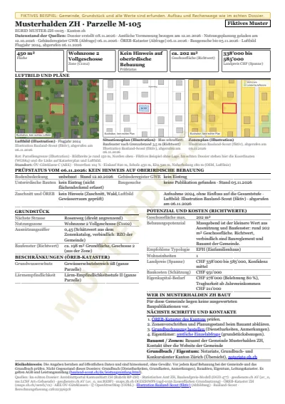
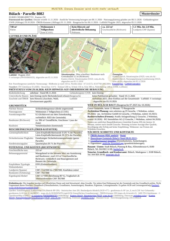
This is what your dossier looks like
For most people, a plot of land is one of the biggest purchases of their life. The dossier helps you check it objectively beforehand.
Before you buy, you see the approximate location as a circle (around 150 m), the zone, a rough size band and, depending on the canton, the municipality’s land price guide value per m² (see coverage by canton). After you buy: the exact plot with its number, exact area, plan and aerial photo, as a PDF to download (several dossiers as a ZIP file with one PDF per plot).
Search plots View sample dossier
For your own home
This fictitious example in «Musterhalden ZH» shows a 450 m² plot and a dream house with one dwelling: land price range, building costs, equity and affordability. For comparison, it also shows the theoretical maximum development. This helps you assess whether a plot might fit your budget.
View the exampleLand price depending on the canton: the dossier currently includes an indicative land price per m² in the cantons of ZH, TG and BL. In the other cantons, ask the municipality, the land registry office, a bank or a valuation office. What the dossier contains in each canton: coverage by canton.
Letter to the land registry: Ready-made letter to the land registry for the ownership information (for 1 to 3 dossiers; from 4 dossiers a guide)
For persons abroad, the purchase may require a permit («Lex Koller»). More on buying from abroad
How to buy
Choose a municipality and view the undeveloped plots, with zone, a rough size band and the location shown as a circle. Free, no account needed.
Pay by TWINT or card and download the dossier straight away as a PDF: exact parcel, area, plan, aerial image and restrictions.
The dossier names the responsible land registry. There you find out who owns the plot and make a personal enquiry. Whether it is for sale remains open.
Private buyers, no account: Choose a municipality, view the plot, buy the dossier. You pay by TWINT or card, without registering and without giving any personal details. The download link appears immediately after payment and is valid for 48 hours; if you wish, we will also send it to you by e-mail (we use the address only for this and delete it afterwards).
The search across all cantons is open without an account.
Existing-building guarantee: if a building with a footprint of at least 12 m² was already standing on the plot at the time of purchase, you receive the dossier price as a credit for your next dossier. This excludes a small structure that the preview flagged before purchase with the note «At least one small structure under 20 m² recorded» and that the dossier mentions. Conditions (Terms and Conditions, section 7a)
Sign up without an account on the page of your municipality and confirm with the link in the e-mail. For 12 months, you receive at most one e-mail a week, and only when new plots appear in the search there. Up to 3 municipalities, unsubscribe at any time with one click. Go to the municipalities
Looking on behalf of a company? Go to the section for companies
For companies
For architecture and planning practices, general contractors, developers, investors, housing cooperatives and estate agencies: screen whole areas, one dossier per plot, packages for a municipality, district or canton, and purchase on invoice with a business account.
| Municipality package | at most CHF 350.– |
|---|---|
| District | CHF 1'500.– |
| Canton | CHF 3'500.– |
| All covered regions (currently 18 cantons) | on request |
The lower amount always applies. If you choose three dossiers, you pay the 3-pack at CHF 140, never the flat rate. From 8 dossiers in one municipality, the municipality package applies because it is then cheaper.
What a package includes: a one-off set of dossiers for all plots that the search shows in the chosen area on the day of purchase, no subscription, no later updates. Municipality, district and canton packages come with a table for your CRM or GIS (CSV), with the same values as the dossiers. Packages are worthwhile for anyone assessing an entire area: developers, architecture practices, estate agencies, investors.
Pay once, no subscription, no follow-up costs. All prices are in CHF and are final prices; Bauland-Scout is not registered for VAT. Private buyers pay by TWINT or card without an account; companies with a business account can also order on invoice.
In your business account you switch on an area watch for a municipality, a district or a canton. You receive an e-mail when new plots enter the results there, or when a plot from one of your purchased dossiers is no longer listed in the search. Only when something changes, at most once a week, can be switched off at any time. Nothing is charged automatically.
Fictitious, fully calculated examples show what the dossier contains and how to work with the figures, including cantons for which the dossier contains no indicative land price or no public-law restrictions extract.
View sample cases (fictitious) View sample dossierQuestions about the area, data status or team? Write to us
Existing-building guarantee: if, at the time of purchase, a building with a footprint of at least 12 m² was already standing on a plot for which you bought a dossier, you receive the dossier price as a credit: without an account as a voucher code, on invoice as a credit note or credit balance, the proportional price for packages. This excludes a small structure that the preview flagged before purchase with the note «At least one small structure under 20 m² recorded» and that the dossier mentions. Conditions (Terms and Conditions, section 7a)
Bauland-Scout finds building-zone plots whether or not they are ever advertised for sale, with a modelled floor area ratio and possible residential units in each dossier; indicative price and indicative yield figures where official price statistics exist (currently in the cantons of ZH, TG and BL).
Every good investment starts on solid ground: knowing where building land is found.
Define your target municipalities. The plots identified as undeveloped, with zone, rough size band (exact area in the dossier) and planning application status (where data are available), at a glance.
Max. gross floor area and possible residential units as modelled values per plot, where a floor area ratio exists (not in TI and GL, not under special building rules). Indicative land price and gross and net yield as modelled values currently only in the cantons of ZH, TG and BL.
The planning application radar flags plots with published planning applications (per canton, where data are available), so you look first at what does not already appear to be taken.
Owner information via the land registry office, through the official procedure, with no bulk enquiries.
If you build, you need land (continuously). Bauland-Scout shows where undeveloped building zones remain in your target areas, which players are active there and which plots have stayed undeveloped in the official data.
A build begins not with the plan but with the land, and that is where we lend a hand.
Screen entire regions in minutes rather than weeks. The building-zone plots identified as undeveloped, by municipality and zone, with a rough size band; exact area and potential in the dossier.
Floor area ratio, typology, max. gross floor area (modelled), PLR restrictions (depending on the canton), an initial preliminary check as an indicative value in the dossier.
Planning application radar per municipality (where data are available): the recorded planning applications and the architecture firms, clients and general contractors named in them.
The official route to the owners, for every plot. Your acquisition does not depend on listings.
Acquisition with substance instead of cold calling: a dossier with a modelled floor area ratio, maximum floor area and indicative feasibility figures opens the door to the landowner, and proves your expertise before you draw the first line.
Before the plans are drawn and laid, we show where building land has stayed.
Undeveloped plots in your catchment area, with zone, shape and surroundings, as a basis for studies and acquisition.
Floor area ratio, max. gross floor area, recommended typology, restrictions, derived from official sources, as indicative values.
Where have planning applications been recorded? The radar shows the available planning applications per municipality. Missing entries may also be due to gaps in the data.
Owner information, then your concept: ‘This is what could be built on your land’, the strongest acquisition argument.
The most convincing first approach to a landowner is not a business card but a well-founded dossier: what the land might be worth, what could be built on it, who is building in the area. Bauland-Scout delivers it ready to print.
Undeveloped plots in your market area, whether or not they are advertised for sale.
Indicative price with a statement of uncertainty (currently in the cantons of ZH, TG and BL), potential, comparable surroundings, figures instead of gut feeling for the conversation with the owner.
Planning application radar (where data are available): where is there movement, where is an approach worthwhile now?
Owner information from the land registry office, an individual letter, professional, through the official procedure, no mass mailings.
From dream to groundbreaking
You drive through a village, see a meadow on a hillside and think: here. But who owns it? Can you build on it? What would it cost?
Bauland-Scout gives you indicative answers in seconds: zone and floor area ratio, modelled possible living space, indicative price (currently in the cantons of ZH, TG and BL), noise, waters, contaminated sites, public transport, as a ready-to-print dossier for each plot. ‘It would be lovely here’ becomes an indication of what might be possible here.
The route to the owners leads through the land registry office, an individual official enquiry, a letter, a conversation. No mass mailings, no data harvesting: the first step towards a plot is a personal enquiry. We show you the way; you take it.
The meadow on the hillside has become an address. This is how it can begin: not with an advert, but with a good question at the right time.
Coverage in Switzerland
AG · AI · AR · BE · BL · BS · FR · GE · GL (2022 zoning status, federal) · GR (partial) · SH · SO · SZ · TG · TI (2022 zoning status, federal) · UR · ZG · ZH: full dossiers with plot, zone, modelled development potential and the route to the owner; indicative land price and PLR extract depending on the canton (see the table below). GR with partial coverage (the canton has so far published land use planning freely for only some of its municipalities). GL, TI: available, zones from the 2022 zoning status (federal, harmonised), not legally binding, current zones from the municipality; no floor area ratio, therefore no modelled development potential. Source of the zones: Federal Office for Spatial Development ARE, cantonal spatial planning offices.
JU · LU · VS: their plot data are subject to a fee or require a licence; we deliberately do not obtain them there. What we provide are the legally binding building zone areas, to view on the aerial photo. For everything else, the direct official route applies: the land registry office (plot, owner) and the municipal building authority. For LU, the route leads to the cantonal geodata shop.
NE: individual dossier per plot. Click on a plot in the building zone, Bauland-Scout retrieves it from the canton (© SITN) and delivers the full dossier.
SG: in preparation, data freely available, permission to pass them on requested from the canton (Oct. 2026). OW, NW: release applied for from GIS Daten AG (autumn 2026). VD: redistribution prohibited, not included. Our principle: what we cannot obtain cleanly and in line with the licence, we do not show. No made-up data.
| Canton | Coverage | Undeveloped plots | Data retrieval | Official source | PLR extract | Indicative land price | Planning applications |
|---|---|---|---|---|---|---|---|
| Aargau (AG) | plot level, full dossier | 5'478 | geodienste.ch (official cadastral survey) · geodienste.ch (land use planning) | in the dossier | not included | not included | |
| Appenzell Innerrhoden (AI) | plot level, full dossier | 140 | geodienste.ch (official cadastral survey) · geodienste.ch (land use planning) | not included | not included | not included | |
| Appenzell Ausserrhoden (AR) | plot level, full dossier | 382 | geodienste.ch (official cadastral survey) · geodienste.ch (land use planning) | not included | not included | in the dossier | |
| Bern (BE) | plot level, full dossier | 5'666 | geodienste.ch (official cadastral survey) · geodienste.ch (land use planning) | in the dossier | not included | in the dossier | |
| Basel-Landschaft (BL) | plot level, full dossier | 2'488 | geodienste.ch (official cadastral survey) · geodienste.ch (land use planning) | not included | in the dossier (average) | in the dossier | |
| Basel-Stadt (BS) | plot level, full dossier | 133 | geodienste.ch (official cadastral survey) · geodienste.ch (land use planning) | not included | not included | in the dossier | |
| Fribourg (FR) | plot level, full dossier | 3'075 | geodienste.ch (official cadastral survey) · geodienste.ch (land use planning) | not included | not included | not included | |
| Geneva (GE) | plot level, full dossier | 1'433 | geodienste.ch (official cadastral survey) · geodienste.ch (land use planning) | not included | not included | not included | |
| Glarus (GL) | plot level, 2022 zoning status (federal, harmonised), not legally binding, current zones from the municipality | 464 | geodienste.ch (official cadastral survey) · Federal Office for Spatial Development ARE, cantonal spatial planning offices (Swiss building zones harmonised, 2022) | not included | not included | not included | |
| Graubünden (GR) | plot level, partial (not all municipalities published freely) | 1'821 | geodienste.ch (official cadastral survey) · geodienste.ch (land use planning) | not included | not included | not included | |
| Neuchâtel (NE) | available, individual dossier per plot (retrieved from the canton); search as zone overview | — | © 2026 SITN · geodienste.ch (land use planning) | not included | not included | not included | |
| Schaffhausen (SH) | plot level, full dossier | 756 | geodienste.ch (official cadastral survey) · geodienste.ch (land use planning) | not included | not included | in the dossier | |
| Solothurn (SO) | plot level, full dossier | 3'570 | geodienste.ch (official cadastral survey) · geodienste.ch (land use planning) | not included | not included | in the dossier | |
| Schwyz (SZ) | plot level, full dossier | 830 | geodienste.ch (official cadastral survey) · geodienste.ch (land use planning) | not included | not included | in the dossier | |
| Thurgau (TG) | plot level, full dossier | 2'589 | geodienste.ch (official cadastral survey) · geodienste.ch (land use planning) | not included | in the dossier | not included | |
| Ticino (TI) | plot level, 2022 zoning status (federal, harmonised), not legally binding, current zones from the municipality | 6'472 | geodienste.ch (official cadastral survey) · Federal Office for Spatial Development ARE, cantonal spatial planning offices (Swiss building zones harmonised, 2022) | not included | not included | not included | |
| Uri (UR) | plot level, full dossier | 269 | geodienste.ch (official cadastral survey) · geodienste.ch (land use planning) | not included | not included | not included | |
| Zug (ZG) | plot level, full dossier | 470 | geodienste.ch (official cadastral survey) · geodienste.ch (land use planning) | not included | not included | in the dossier | |
| Zurich (ZH) | plot level, full dossier | 4'516 | geodienste.ch (official cadastral survey) · Canton of Zurich, geodata (maps.zh.ch) | in the dossier | in the dossier | in the dossier | |
| Jura (JU) | zone overview (plot data not freely available) | — | geodienste.ch (land use planning) | — | — | — | |
| Lucerne (LU) | zone overview (plot data not freely available) | — | geodienste.ch (land use planning) | — | — | — | |
| Valais (VS) | zone overview (plot data not freely available) | — | geodienste.ch (land use planning) | — | — | — | |
| Total | 18 cantons at plot level | 40'552 |
18 cantons with vacant lots (at plot level), plus individual dossiers per plot in NE, plus a zone overview in JU · LU · VS. Last updated:
Indicative land price: currently in the cantons of ZH, TG and BL, from the public statistics of the canton; the source, period and type of figure (range around the median or average) are stated in the dossier. For the other cantons we have no current public statistics per municipality. You can enquire about a guide value at the municipality, the land registry office, a bank (for example your cantonal bank) or a valuation office.
→ Scope of services & data quality in detail (what you receive, what you do not, and where the gaps are and why).
Building land by canton: Aargau · Appenzell Ausserrhoden · Appenzell Innerrhoden · Basel-Landschaft · Basel-Stadt · Bern · Fribourg · Geneva · Glarus · Graubünden · Schaffhausen · Schwyz · Solothurn · Thurgau · Ticino · Uri · Zug · Zurich · all cantons
The vacant lot is there, just out of sight. We bring it into the light.
No marketing figures: what we count are building-zone plots from the official cadastral survey that are identified as undeveloped in the data analysed, cross-checked with the Federal Register of Buildings and Dwellings and land cover data, and with available planning application data (per canton, where available). A plot only counts as a vacant lot if a building envelope of at least 200 m² remains after a boundary distance of 3.5 m; small gardens next to built-up plots, largely paved areas and remnant plots do not count. The information is for guidance only. Whether building is permitted is for the municipal building authority to say; whether a plot is sold is for the owners alone to decide.
Aerial image check: 21'276 of the 40'552 plots carry the mark «Aerial image checked: nothing noticeable». On the evaluated aerial image (swisstopo, flight years 2021 to 2025), no building and no installation was detected on the plot (except small structures under 12 m²), and no building of 12 m² or more is recorded in the official cadastral survey (status per canton 29.10.2026 to 04.11.2026). Trees and shrubs are possible; in this evaluation, vegetation does not lead to the classification «to be clarified on site». The check is automatic, on our own infrastructure. Every plot is checked on the aerial image and in the official cadastral survey. In two randomly drawn samples of 150 plots each, separate image evaluations supported the finding in 86 to 95 % of cases, depending on the counting method (status 04.11.2026; method: bauland-scout.ch/en/methode.html). The mark is an indicative value and does not replace a site visit or information from the building authority.
Transparency
Bauland-Scout does not provide this information: nor any owner data. Every dossier names the route there: the competent office, contact details and the documents required.
Risk notice. The information is based on public data and is indicative only, without warranty. Before any purchase, check the building status with the municipality and the land register. Full notice (scope of service)
Who is behind it
Founded by Roland Hafner, Uster.
Frequently asked questions
Bauland-Scout analyses Switzerland’s official cadastral survey and land use planning and identifies building-zone plots that are undeveloped in these data. They are automatically cross-checked against the Federal Register of Buildings and Dwellings (GWR) and underground structures, and with available planning application data (per canton, where available; otherwise the dossier states ‘Planning application data not available’ and that cross-check has not been made). This produces 40'552 undeveloped plots in 18 cantons, automatically cross-checked against official registers, whether or not a plot is advertised for sale. Whether and how building is permitted is for the municipal building authority to say.
The page Building land by municipality shows, for every municipality covered, how many undeveloped plots in the building zone the official data show, broken down by zone and with the date of data retrieval. In the cantons covered at plot level, the search then shows each plot with its zone and approximate location; the dossier names the plot and gives all the details.
Land prices depend heavily on the municipality, location and zone, so we do not quote a single figure for an entire canton. Where official price statistics exist (currently in the cantons of ZH, TG and BL), the dossier contains an indicative price for the individual plot, with the source and the method used. It is a modelled value, not a valuation and not an offer. For the other cantons we have no current public statistics per municipality; you can enquire about a guide value at the municipality, the land registry office, a bank (for example your cantonal bank) or a valuation office.
The competent authority is the land registry office of the canton or of the municipality where the plot is located. You can find out there who owns a plot, in principle without proof of interest (Art. 970 para. 2 Swiss Civil Code), and in some cantons also online for individual plots. For further information, such as easements, the office requires proof of interest. Bauland-Scout does not provide owner data and makes no bulk enquiries; every dossier names the competent office and the route to an individual enquiry.
The plot number and plan are shown on your canton’s geoportal (GIS) or on the federal map viewer, map.geo.admin.ch. A purchased Bauland-Scout dossier contains the plot number, area, zone, site plan and aerial photo with the plot boundary from the official cadastral survey, plus a link to the official cadastral plan, for information only, not an extract. You can obtain a certified cadastral extract (land register plan) from the surveyor responsible for updating the survey or from the land registry office.
The canton’s GIS browser or geoportal shows all official maps for a place you look up yourself. Bauland-Scout combines official geodata from the cantons and the Confederation (official cadastral survey, zoning plan, buildings register, PLR cadastre, available planning applications) and filters out the plots in the building zone that are identified as undeveloped in these data, for entire municipalities and cantons, with a dossier for each plot. It replaces neither the cantonal geoportal nor the legally binding PLR cadastre.
Plot, zone and restriction data come exclusively from official sources: the official cadastral survey (geodienste.ch), cantonal land use planning (for GL, TI, as a substitute, the 2022 federal zoning status, harmonised and not legally binding; source: Federal Office for Spatial Development ARE, cantonal spatial planning offices), the Federal Register of Buildings and Dwellings (GWR), the PLR cadastre, the official gazette portal and swisstopo. Distances to local amenities come from OpenStreetMap (© OpenStreetMap contributors, ODbL); development potential, price and cost figures are our own modelled values based on official data and statistics. All information is for guidance only and not binding on landowners (an orientation, not legally binding information).
18 cantons at plot level (AG · AI · AR · BE · BL · BS · FR · GE · GL (2022 zoning status, federal) · GR (partial) · SH · SO · SZ · TG · TI (2022 zoning status, federal) · UR · ZG · ZH) with a full dossier per plot. 18 cantons with vacant lots (at plot level), plus individual dossiers per plot in NE, plus a zone overview in JU · LU · VS. Gaps are honestly declared; details on the Scope of services page.
A single plot dossier costs CHF 60. Any three dossiers, also from different municipalities, cost CHF 140 as a 3-pack, compared with CHF 180 for three single dossiers (you save CHF 40). A municipality package costs at most CHF 350, a district CHF 1'500, an entire canton CHF 3'500. All covered regions (currently 18 cantons): on request. The lower price always applies: if you choose three dossiers, you pay the 3-pack, never the flat rate. All prices are in CHF and are final prices. Bauland-Scout is not registered for VAT; no VAT is charged. Private buyers pay by TWINT or card without an account; companies with a business account can also order on invoice.
No. Bauland-Scout is not an estate agent and not a listings portal: it neither sells nor brokers land. It shows where undeveloped building land is located and provides a dossier for each plot. Whether a plot is sold is for the owners alone to decide; you make contact yourself, through the official route.
Listings portals such as ImmoScout24 or Homegate only show plots that are already for sale. The canton’s PLR portal provides, for a plot you already know, an official PDF extract of the public-law restrictions on landownership; map.geo.admin.ch shows the official maps. Bauland-Scout adds an area-wide search for candidate plots and its own analyses: it filters the official data for building-zone plots identified as undeveloped and provides a dossier for each plot. Valuation services and plot analysis tools assess a plot you already know: what it is worth or what may be built on it. Bauland-Scout starts one step earlier and helps you find undeveloped plots in the first place.
No. Bauland-Scout automatically cross-checks the plots against the buildings register, underground structures (underground car parks) and, per canton where available, published planning applications; where no planning application data exist, this cross-check has not been made. Critical cases are clearly marked ‘Status uncertain’. We only count plots as vacant lots if a building envelope of at least 200 m² remains after a boundary distance of 3.5 m; small gardens next to built-up plots and largely paved areas do not count. Even then a plot may turn out to be a garden or car park on site: check the aerial image in the dossier and ask the building authority. Whether a plot is sold is for the owners alone to decide.
The guarantee applies from a building with a footprint of 12 m². A small structure with a registered area of less than 20 m² that is shown in the preview before purchase as recorded in the buildings register and is mentioned in the dossier is excluded, because you know about it before buying. Conditions: Terms and Conditions, section 7a.
Bauland-Scout counts plots without a recorded building in the building zone. Every plot is also checked on the aerial image (swisstopo) and in the official cadastral survey. «Aerial image checked: nothing noticeable» means that no building and no installation was detected on the aerial image (except small structures under 12 m²) and that no building of 12 m² or more is recorded in the official cadastral survey; trees and shrubs are possible. «Aerial image checked: to be clarified on site» means that at least one circumstance calls for a check, for example a garden or a paved area; the dossier lists every reason. The mark is an indicative value and does not replace a site visit or information from the building authority. How the check works and what the samples showed is explained on the Method page.
The acquisition of real estate in Switzerland by persons abroad is in principle subject to restrictions and may require authorisation (Federal Act on the Acquisition of Real Estate by Persons Abroad, BewG, «Lex Koller»). Exceptions are decided by the cantonal authority. This is not legal advice.
Under the Federal Act on the Acquisition of Real Estate by Persons Abroad («Lex Koller»), the following may buy without authorisation: Swiss citizens; EU and EFTA nationals with lawful and actual residence in Switzerland; nationals of other countries holding a valid C settlement permit. Nationals of other countries holding a B residence permit with lawful and actual residence in Switzerland may acquire, without authorisation and at their place of residence, a dwelling or a plot for their own main residence (Art. 2 para. 2 let. b of the Act): in their own name, a single dwelling unit, lived in by themselves and not let; for building land, construction must start within about one year. The area must not exceed what is required for use as a main residence; for plots exceeding 3000 m², the land registry office generally refers you to the authorisation authority for assessment. Other acquisitions by persons abroad generally require authorisation. Status November 2026: a proposed revision would require authorisation for acquisitions of a main residence by persons abroad that are currently exempt; it is not in force. If in doubt, ask the cantonal authorisation authority before buying. Source: Federal Office of Justice. This note is not legal advice. General information: persons abroad.
No. Bauland-Scout does not sell land, it sells dossiers: reports on undeveloped plots in the building zone, with zone, area, restrictions and the official route to the owners. Whether a plot is for sale is an open question; that is for the owners alone to decide. You agree any purchase directly with them. In Switzerland, buying land requires a notarised deed (public certification) and entry in the land register.
The page Building land by municipality or the search shows you where undeveloped plots in the building zone lie in your municipality. The dossier for a plot sets out the zone, area, restrictions and the competent land registry. The land registry tells you who owns the plot, and you can then contact the owners personally. Whether they want to sell is an open question. What may be built, and how, is decided by the municipal building authority.
Yes. The page For property owners explains what Bauland-Scout shows (approximate location and zone, no names of owners) and where the data comes from. There you can ask that your plot no longer appears in the search, report an error or request information under the Data Protection Act. So that nobody can have someone else's plot removed, we check before removing it whether the plot belongs to you or whether you represent the owners.
Have you found a plot with Bauland-Scout? Tell us about it, anonymously.
Questions about an area, about all covered regions at a flat rate, or suggestions and complaints: we read every message and reply personally, usually within 2 working days.
Advertising and sales solicitations to this address are unwanted.